 I listened-in on a conference call with the National Hurricane Center early this week as the remnants of Hurricane Gustav spun lazily across northeast Texas.
The forecaster presenting the tropical weather outlook to emergency responders and government officials noted that Sept. 10 marks the peak of hurricane season.
Even without that reminder, a look at the satellite image of a swath of ocean stretching from Africa to Texas told the story: storms lined-up like MD-80s awaiting takeoff at Dallas-Fort Worth International Airport.
Batteries. Ice. Bottled water. Gas for the generator, if you have a generator. Radio. Full tank of gas. Bathtub full of water. Candles. Easy Cheese and saltines. That's some of what you'll need if you decide to ride-out a hurricane on the central Texas coast.
My acquaintance with tropical cyclones began early; when I was a young child, Grandma had two cats, Celia and Beulah, who had shown up on her doorstep a few blocks from the bay during their namesake storms (1970 and 1967, respectively).
Aransas County schools didn't have snow days built-in to the schedule, but we did have hurricane days, and a tropical storm could trigger a closing. I remember the feeling of awe I felt the first time I watched the harbor rise and cover downtown streets, including the old H-E-B parking lot.
 Hurricane Allen, which made landfall in early August of my 11th year was memorable for being a three-time Category-Five storm. It weakened before making landfall between Brownsville and Corpus Christi, but not before my father had evacuated the family to higher ground.
Whether you stay or you leave, you'll want lots of plywood. Seasoned hands keep it on-hand to avoid lines and shortages right before a storm. The plywood, by the way, will cover your windows.
Some of the costliest storms haven't been ones with big Saffir-Simpson numbers (the scale, from 1-5, categorizes storms according to sustained wind intensity with Category Five being the strongest).
I recall one storm in the 1980s that we didn't take-off for. I remember the way the sky turned green in the east and the eery stillness of the eye. And I remember boats pushed across Highway 35 and piles of shell on beachfront roads and the wreckage of piers and snakes ... lots and lots of snakes. In the bayside towns of the Texas coast, we especially watch out for rattlesnakes. The storm surge and pounding surf on the barrier islands sweeps lots of wildlife off toward the mainland.
Tropical Storm Charley was the one that introduced me to cyclones as part of my work. The storm came ashore Aug. 21 right over Rockport before hanging a left and moving across the South Texas brush country. Over Val Verde County, Charley dumped more than a year's worth of rainfall in 24 hours.
A flash flood wiped-out the oldest section of the town of Del Rio, century-old adobe homes. Some of the inhabitants were never found. I spent the second night of the storm riding a 5-ton truck, picking up people who were stranded and handing-out bottled water at local shelters. I spent the next day chronicling the experience and making sure the AP had a spot on a helicopter.
 In September, I chased Frances, a strong tropical storm, from Corpus Christi to High Island.
I like to have a couple of Jimmy Buffet cassettes, or nowadays disks or mp-3s, handy in a battery-powered boombox. "Trying to Reason with Hurricane Season" is a great one, obviously. The Internet is a real boon in this regard; with enough advance notice, you can probably put together an entire album's-worth of songs that either mention the name of the upcoming cyclone or the word "hurricane."
A little more than a month later, Hurricane Mitch slammed into Honduras. The deadliest Atlantic storm since the Great Hurricane of 1780, Mitch knocked the Galveston Hurricane of 1900 out of second-place on the list of deadliest storms.
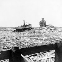 Some 12,000 people died, with almost as many reported missing. I ended-up spending Thanksgiving and Christmas in El Salvador. Mitch was only a Category One storm when it made landfall.
By 2001, I was an on-call PIO with the Texas Division of Emergency Management, and ended up working nearly a month at the FEMA disaster recovery center in northwest Houston after Tropical Storm Allison dropped as much as 40 inches of rain over southeast Texas, leaving about 70,000 homes flooded and 30,000 people without even wet homes.
Now that I'm older, of course, I also make sure to hit the liquor store well before the eve of a hurricane. There is, in fact, a long tradition of "hurricane parties." Nothing worse than being stuck in a storm sober.
Hurricane Claudette was a strong Cat-One storm which made landfall just north of Rockport in 2003. For me, it is memorable mostly because my brother drove a brand-new Aransas County Sheriff's Office patrol car through a 4-foot-deep intersection. That was the end of the car, but John's law enforcement career continued.
I remember well Hurricane Rita, the second of 2005's one-two puch. For a week Rita appeared to be drawing a bead on the Port Aransas area. I worried about how best to prepare a 12-and-a-half ton sailboat to ride-out the storm.
 In the end, for the Texas Coastal Bend, Rita was simply another harbor-over-the-parking lot event. Following so closely on the heels of Hurricane Katrina, Rita prompted the complete evacuation of Corpus Christi. Even the evacuees from Louisiana, sleeping on cots in the Corpus Christi Colliseum, had to go.
I was already doing hurricane-related duty at the time, as the agency I worked for attempted to reunite children and parents who had been separated from one another in the chaos of Katrina.
Have a family emergency plan that includes a friend or relative's phone number -- someone well out of the path of the storm -- where you can call to leave messages and get information if you're separated. Make sure the kids know the number.
 Recently, preparing for likely questions I'd face on a TV morning show, I scribbled-down the effects of a hurricane on the natural environment. Hurricane Dolly had just come ashore around Port Mansfield. I looked at the answer I was formulating and thought: "I'd better check that."
If you're diabetic and your insulin has to be refrigerated, you get a lot of ice, just to make sure. A camp stove and bottled fuel is another good idea; even though it will be sweltering in the wake of the storm, you may want a hot meal. You also may have to boil water.
A coastal fisheries biologist confirmed the common wisdom I'd grown up with: "We need a good storm to flush out the bay." In fact, tropical weather systems are important sources of freshwater inflow and typically are good for the environment in the long term. I think of it as our corner of the planet breathing in, breathing out.
Truly, I view the approach of tropical weather much more calmly now that I no longer have a 30-foot sailboat to worry about and now that my elderly grandparents are no longer in Rockport. I'm also a good 200 miles from the coast and 500 feet above sea level.
With much of the rest of the nation, I was stunned by the immense suffering in New Orleans during and after Hurricane Katrina. Our government can do better. I've seen it do better.
 I have a confession: I like tropical storms. The feeling in the pit of my stomach when the bottom drops out of the barometer. The funky sky color. The wind and rain. I even like NOAA's pictures -- the fiery shades marking rainfall and wind intensity, the serene spirals of water vapor satellite imagery. The follow-the-dots tracks.
At least the National Weather Service is on the ball. They predicted Katrina's effects and path with great accuracy, and they've been pretty close to the mark on a lot of other storms recently. Take a look at what's out there now.
[Photos courtesy NOAA, Wikimedia Commons]

 Before Ike, before I went to Anahuac and the Bolivar Peninsula, I wrote that I actually like tropical storms. Not so much, now. The devastation I have witnessed and so many have lived in Southeast Texas is sobering.


